Devil's Mill Gorge - Campulung Moldovenesc - video

The Devil's Mill Gorge is relatively short, measuring only 60 to 70 meters in length. It was formed in yellowish-gray-white dolomite by the work of a stream that crosses the gorge, as a result of erosion and the dissolution characteristic of limestone. In several places, you can observe overhanging rock walls and stone basins, which indicate former cave passages that have collapsed in the past.
Read more
Filmed with GoPro HERO5 Black. Music: Homelands Ashes by Kai Engel. Copyright © 2017 - 2025 Geo Trekker Videos.
Already published 8162 photos and 136 videos. Please register for full access.
Photos of nearby places


[ Top ↑ ]
Videos of nearby places
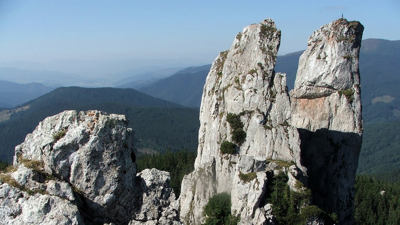
Lady's Stones - Rarau Mountains 4.82 km away
The Lady's Stones represent the heart, the mind, and the soul. The first two only help to understand the world when one possesses knowledge (they can be climbed with rock climbing gear), as emotions and thoughts (the two rock towers) obscure reality (the view).

With snowshoes in the Tihu creek valley - Rastolita 56.53 km away
We met geotrekking treasure hunters from Gheorgheni, Miercurea Ciuc and Targu Mures in Rastolita. We entered the Calimani Mountains with an off-road vehicle, along the Rastolita and Tihu streams.

Via ferrata Bear Cave adventure and climbing zone - Borsec 56.74 km away
The Bear Cave in Borsec is a vast natural formation, scattered with rocks and deep crevices. Access to the cave's cavities is through a series of narrow formations resembling canyons, surrounded by giant fir trees and rocks with interesting shapes.

Astragalus iron path in winter - Glod Stone, Munticelu 74.34 km away
The official website of the Sugau Gorges published information about a new via ferrata climbing route named Astragalus. Sugau Gorges - Munticelu is a nature conservation area part of Natura 2000 located in Neamt County, which borders Harghita County.

Waterfalls of Lapos creek - Bicaz Gorges 75.29 km away
One of the lesser-known attractions of the Bicaz Gorges is the series of waterfalls along Lapos Creek. This creek flows between Cupas Stone and Bardos Stone before eventually merging with Bicaz Creek, forming spectacular waterfalls beneath the Altar Stone.
Other places
Lookout Kis-Tubes Western Mecsek 583.65 km away
The lookout platform at Kis-Tubes, located at an altitude of 577 meters, was built in 1959, and offers a magnificent panorama of Pécs at the foot of the hills. The concrete lookout, situated on the western side of the Kis-Tubes peak along the ridge connecting Misina to Tubes, was designed by Tibor Kiss.
The lookout platform at Kis-Tubes, located at an altitude of 577 meters, was built in 1959, and offers a magnificent panorama of Pécs at the foot of the hills. The concrete lookout, situated on the western side of the Kis-Tubes peak along the ridge connecting Misina to Tubes, was designed by Tibor Kiss.
Babsko Praskalo waterfall Tazha 532.29 km away
In the Central Balkans National Park, there are many rivers that cascade down spectacular waterfalls, which the locals call praskalo. One of the smallest waterfalls in the area is Babsko Praskalo, which stands at only 54 meters high.
In the Central Balkans National Park, there are many rivers that cascade down spectacular waterfalls, which the locals call praskalo. One of the smallest waterfalls in the area is Babsko Praskalo, which stands at only 54 meters high.
Orlovo Oko (Eagle's Eye) Yagodina 656.2 km away
Orlovo Oko (Eagle's Eye) is a lookout viewpoint located in the Rhodope Mountains, near the peak of Saint Ilia and close to the village of Yagodina, Bulgaria. The steel structure, built at an altitude of 1,563 meters, rises 670 meters above the spectacular Buynovsko Gorge, along with the winding river and road that traverse it.
Orlovo Oko (Eagle's Eye) is a lookout viewpoint located in the Rhodope Mountains, near the peak of Saint Ilia and close to the village of Yagodina, Bulgaria. The steel structure, built at an altitude of 1,563 meters, rises 670 meters above the spectacular Buynovsko Gorge, along with the winding river and road that traverse it.
Óbányai Valley Eastern Mecsek 567.06 km away
The Óbányai Valley is located in the Eastern Mecsek Landscape Protection Area, stretching between Óbánya and Kisújbánya. Its attractions include the Slanting waterfall or Fairy Stairs, and the Dripping Rock.
The Óbányai Valley is located in the Eastern Mecsek Landscape Protection Area, stretching between Óbánya and Kisújbánya. Its attractions include the Slanting waterfall or Fairy Stairs, and the Dripping Rock.
Key Gorge (Cheii Gorge, Cheile Cheii) Buila-Vanturarita National Park, Capatana Mountains 270.71 km away
The Key Gorge (Cheii Gorge, Cheile Cheii) is located in the Buila-Vanturarita National Park within the Capatana Mountains. It is one of the most beautiful and picturesque gorges in Romania.
The Key Gorge (Cheii Gorge, Cheile Cheii) is located in the Buila-Vanturarita National Park within the Capatana Mountains. It is one of the most beautiful and picturesque gorges in Romania.
[ Top ↑ ]
[ Top ↑ ]
Copyright © 2003-2025 Trekkingklub and friends. Reproduction of any text, picture or video from this website, either in printed or electronic form, is prohibited without prior written permission. Nearby settlements: Slatioara 4.08 km away, Tourist attractions Campulung Moldovenesc 7.23 km away. The given distances are to be understood as straight line distances, and are approximate. Website made in Miercurea Ciuc  .
.