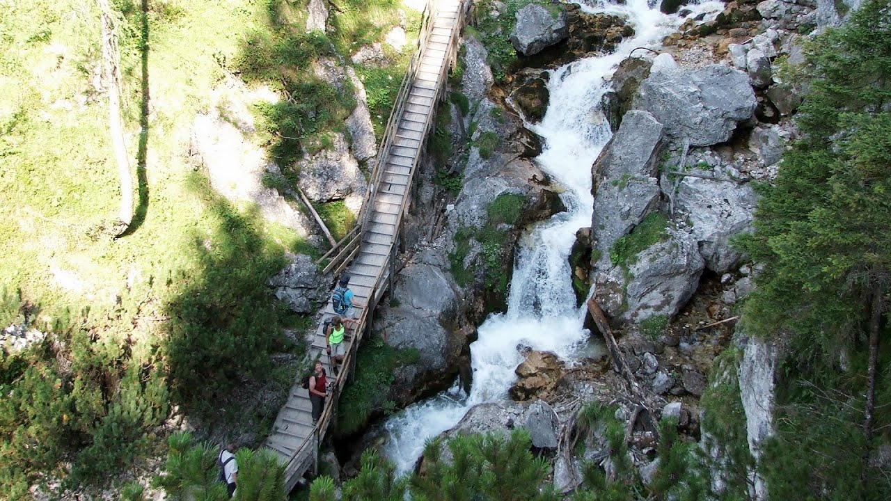
Rosina via ferrata - Silberkar Gorge, Ramsau am Dachstein - video

The Rosina via ferrata is the most difficult via ferrata in the Silberkar Gorge (Silberkarklamm), has a D difficulty rating, and it is a vertical masterpiece. After a short suspension bridge above the stream, it leads up the rock wall next to the gorge waterfall, all the way vertically. Read more
Filmed with SJCAM SJ5000 Plus. Music: The Price Of Valour by Kai Engel. Copyright © 2015 - 2025 Geo Trekker Videos.
Already published 8162 photos and 136 videos. Please register for full access.
Photos of nearby places

Kanin cableway and ski resort - Shooting window, Monte Forato, Bovec, Sella Nevea (48 photos) 121.26 km away
The Kanin Mountains are located in the Western Julian Alps, on the border of Slovenia and Italy. The highest peak in this range, known as (High) Kanin or Monte Canin Alto, in Slovenian and Italian respectively, reaches a height of 2,587 m above sea level.

The Devil's Bridge (Teufelsbrücke) - Wegscheid, Austria (18 photos) 122.66 km away
The Devil's Bridge, Teufelsbrücke in German, is located just ten kilometers from the city of Mariazell, near the Klettersteigpark Spielmäuer via ferrata park. From the top of the via ferrata park, it is worth taking a detour to the Devil's Bridge, which is located near the starting point of the descent path.

Mariazell climbing route, Felix's Celestial Ladder, Devil's Bridge - Climbing Park Spielmäuer (60 photos) 123.55 km away
Climbing Park Spielmäuer - Mariazell climbing route, Felix's Celestial Ladder, Devil's Bridge (Kletterpark Spielmäuer - Mariazeller Steig, Felix Himmelsleiter, Teufelsbrücke) - Wegscheid, Austria.

Boka Waterfall - Slovenia (11 photos) 125.63 km away
Boka (Slap Boka) is a waterfall in western Slovenia, near the Soca River. It has two stages, with the first being 106 m high and 18 m wide, and the second being 33 m high.

Slap Savica waterfall - Slovenia (12 photos) 127.57 km away
Slap Savica, found in the northwestern part of Slovenia, is a magnificent, 78 m high waterfall. It derives its water from a karst spring called Savica located just above the falls.

Lake Bohinj - Upper Carniola, Slovenia (10 photos) 129.77 km away
Lake Bohinj, also known as Bohinjsko jezero in Slovene and Wocheiner See in German, is the biggest permanent lake in Slovenia, covering a vast area of 318 hectares. Situated in the Bohinj Valley of the Julian Alps, in the northwestern region of Upper Carniola (Gorenjska, Alta Carniola, Oberkrain), it forms a part of the Triglav National Park.

Vogel Ski Resort - Slovenia (33 photos) 131.01 km away
Vogel Ski Resort is situated in Slovenia, above Bohinj and adjacent to Lake Bohinj, on the outskirts of Triglav National Park. The resort derives its name from the nearby Mount Vogel, and was established in 1964.
[ Top ↑ ]
Videos of nearby places
Hias via ferrata - Silberkarklamm, Ramsau am Dachstein 0.1 km away
The Hias via ferrata in the Silberkar Gorge (Silberkarklamm) is the first of the three via ferrata routes, and perhaps the easiest to complete. Two cable bridges and a few trickier sections make it interesting, but it is truly impressive due to the view of the narrow gorge.
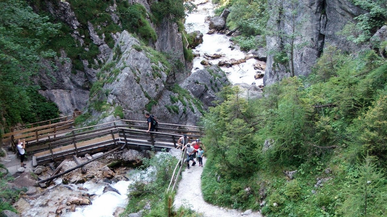
Silberkar Gorge (Silberkarklamm) - Ramsau am Dachstein, Austria 0.28 km away
One of the most beautiful hiking spots in the area of Ramsau am Dachstein, is the Silberkarklamm. It is possible to drive to the entrance of the gorge, there is parking available on the side of the road, and you have to pay an entrance fee.
Siega via ferrata - Silberkar Gorge, Ramsau am Dachstein 0.8 km away
The Siega via ferrata, categorized as a C/D level of difficulty, is perhaps the least interesting of the three via ferrata routes in the Silberkar Gorge (Silberkarklamm). This doesn't mean that it's not good, just that the other two are even better.
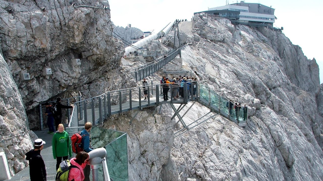
Sky Walk, Suspension Bridge, Stairway to Nothingness - Styria, Dachstein 7.62 km away
The Dachstein cable car (Gletscherbahn Panorama Gondel, Panorama Cable Car) took me up to a height of 2700 meters, to the highest mountain in Styria (Steiermark), the Dachstein. Next to the upper station of the cable car there are several tourist attractions.
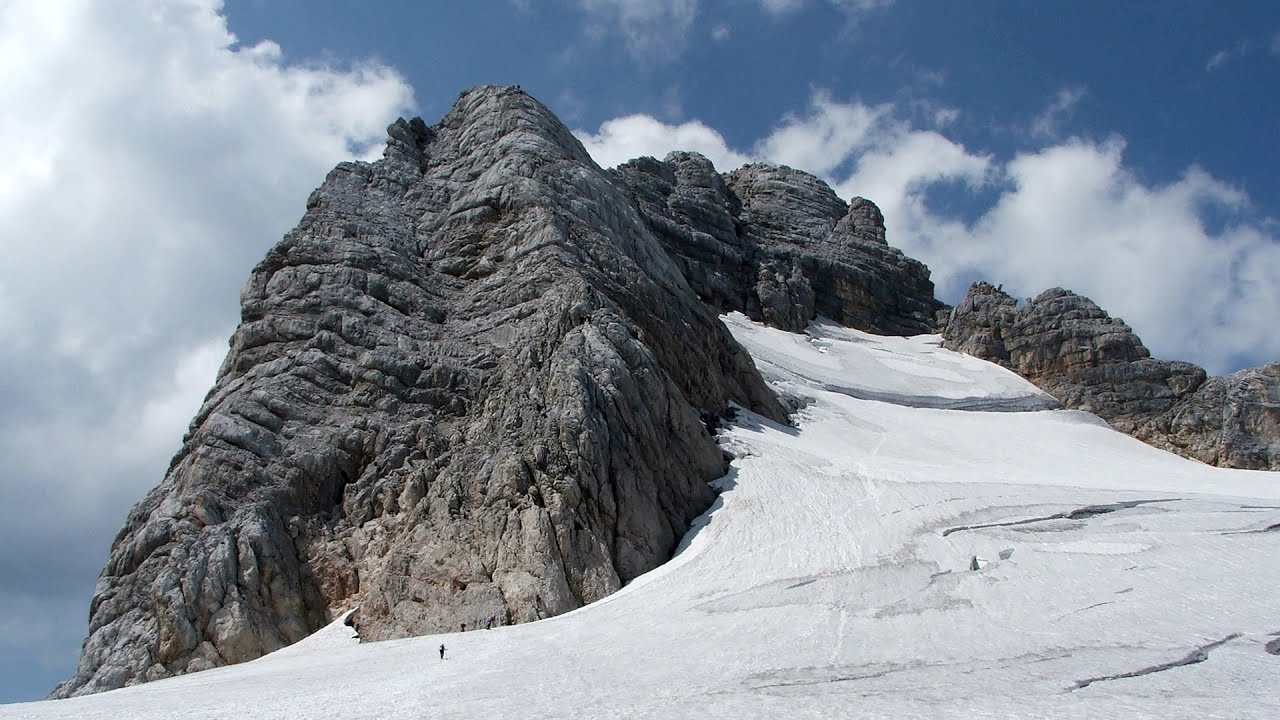
Schulter Anstieg klettersteig - Hoher Dachstein 8.92 km away
Two routes lead to the top of the Hoher Dachstein. The Randkluft is shorter, but can only be reached through a glacier with cracks.
Other places
Lonely Stone (Piatra Singuratica) Hasmas Mountains 920.17 km away
On June 1, 2003, with a small group of friends, I left Balan, walking along the valley of the Sep (Beautiful) stream towards the Lonely Stone (Piatra Singuratica). Those who were with me at the time fell behind, and then other people joined for the hike.
On June 1, 2003, with a small group of friends, I left Balan, walking along the valley of the Sep (Beautiful) stream towards the Lonely Stone (Piatra Singuratica). Those who were with me at the time fell behind, and then other people joined for the hike.
Prohodna cave (The Eyes of God) Karlukovo 937.46 km away
The cave nicknamed The Eyes of God is located in Bulgaria, in the Iskar Gorge, on one of the largest karst areas in Bulgaria, 2 km from the town of Karlukovo. It is essentially a 262-meter-long natural stone bridge, with a large (45 m high) and a small (35 m high) entrance.
The cave nicknamed The Eyes of God is located in Bulgaria, in the Iskar Gorge, on one of the largest karst areas in Bulgaria, 2 km from the town of Karlukovo. It is essentially a 262-meter-long natural stone bridge, with a large (45 m high) and a small (35 m high) entrance.
Devetashka cave Devetaki 989.07 km away
The Devetashka Cave is located in Bulgaria, near the village of Devetaki. After the entrance portal, which measures 30 m by 35 m, there is a vast open chamber that is 110 meters wide and 359 meters long.
The Devetashka Cave is located in Bulgaria, near the village of Devetaki. After the entrance portal, which measures 30 m by 35 m, there is a vast open chamber that is 110 meters wide and 359 meters long.
Via Ferrata Centenario C.A.O Monte Grona, Prealpi Lombarde, Lombardia 375.68 km away
In the magnificent rocky world of Monte Grona, the Centenario via ferrata leads upwards, which I had the opportunity to climb accompanied by lizards. Although it was cloudy and gloomy, I had a great view of Lake Lugano and Lake Como along the way.
In the magnificent rocky world of Monte Grona, the Centenario via ferrata leads upwards, which I had the opportunity to climb accompanied by lizards. Although it was cloudy and gloomy, I had a great view of Lake Lugano and Lake Como along the way.
Meziad cave Padurea Craiului Mountains 667.16 km away
The Meziad Cave is located near the village of Meziad, 22 km north of Beius, in the Padurea Craiului Mountains. It is one of our first tourist caves, its exploration is associated with the name of Gyula Czárán, cave researcher and writer.
The Meziad Cave is located near the village of Meziad, 22 km north of Beius, in the Padurea Craiului Mountains. It is one of our first tourist caves, its exploration is associated with the name of Gyula Czárán, cave researcher and writer.
[ Top ↑ ]
[ Top ↑ ]
Copyright © 2003-2025 Trekkingklub and friends. Reproduction of any text, picture or video from this website, either in printed or electronic form, is prohibited without prior written permission. The given distances are to be understood as straight line distances, and are approximate. Website made in Miercurea Ciuc  .
.