Dark Blue Bruises of the Ponor (Vanatarile Ponorului) - Trascau Mountains - photos


Page no. 1, photos: 1-6, 16 photos in total. >>>

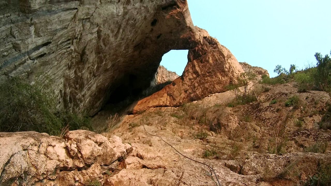
The Dark Blue Bruises of the Ponor (Vanatarile Ponorului) is a polje-type protected area. Polje is a Slovenian word meaning plain, and it refers to a surface karst form. It is a spacious, underground-drained basin with a flat bottom that contains a permanent or periodic water network. During heavy rainfall, the water cannot drain quickly, and a temporary lake forms.
Read more
Copyright © 2006 - 2025 Trekkingklub.com.
Already published 8162 photos and 136 videos. Please register for full access.
Photos of nearby places


Dark Blue Bruises of the Ponor (Vanatarile Ponorului), Bedeleu - Trascau Mountains (24 photos) 2.94 km away


[ Top ↑ ]
Videos of nearby places
Hili cove iron path - Turda Gorges 27.38 km away
While the first time I climbed this via ferrata in the morning, now I climbed it in the light of the setting sun. The red-dressed rocks created a special atmosphere, and I could admire the sunset from the top of the climbing route.

Black Rocks iron path - Bihor Mountains 65.52 km away
Black Rocks is located in the Bihor Mountains, near the Vartop Saddle, to the west of it. It is interesting that the locals (if I understood correctly) do not know this name, but use the name Piatra Buna (meaning Good Stone) for this spectacular rock.

Meziad cave - Padurea Craiului Mountains 86.77 km away
The Meziad Cave is located near the village of Meziad, 22 km north of Beius, in the Padurea Craiului Mountains. It is one of our first tourist caves, its exploration is associated with the name of Gyula Czárán, cave researcher and writer.

Crystal Cave at Farcu Mine 93.46 km away
In the Padurea Craiului Mountains, near Rosia, in the Farcu bauxite mine, in 1987, the miners accidentally discovered a cave. It was filled with crystal-shaped limestone formations.

Hodoaba Valley iron path - Suncuius 93.52 km away
The Hodoaba Valley iron path is Romania's shortest and easiest (official) via ferrata route. It is located near Suncuius, in the Padurea Craiului Mountains, on the left bank of the Crisul Repede River.
Other places
Aareschlucht Meiringen-Innertkirchen, Switzerland 1164.59 km away
The Aareschlucht is a 1400-meter long, 200-meter deep gorge of the Aare river, near Innertkirchen, Switzerland. It has two entrances, one from Meiringen in the west, and one from Innertkirchen in the east, which lead into the narrow, but stunning gorge.
The Aareschlucht is a 1400-meter long, 200-meter deep gorge of the Aare river, near Innertkirchen, Switzerland. It has two entrances, one from Meiringen in the west, and one from Innertkirchen in the east, which lead into the narrow, but stunning gorge.
Neviastata ecopath and iron path Smolyan 539.91 km away
The Neviastata eco-trail is located in Bulgaria, nestled in the heart of the Rhodope Mountains, between Smolyan and Pamporovo. Here, you will find a small, paid adventure park.
The Neviastata eco-trail is located in Bulgaria, nestled in the heart of the Rhodope Mountains, between Smolyan and Pamporovo. Here, you will find a small, paid adventure park.
Balázs Hill Lookout Western Mecsek 409.08 km away
The Balázs hill lookout, located at an altitude of 320 meters, offers a beautiful view of Lake Pécs and the wooded mountain ranges of Western Mecsek. The original lookout, built in 1975, was destroyed by fire, and it was rebuilt in 2001 using a metal structure, which was renovated in 2014.
The Balázs hill lookout, located at an altitude of 320 meters, offers a beautiful view of Lake Pécs and the wooded mountain ranges of Western Mecsek. The original lookout, built in 1975, was destroyed by fire, and it was rebuilt in 2001 using a metal structure, which was renovated in 2014.
The Gorges of the Méouge Ribiers, Upper Alps 1397.55 km away
Following today's climb, I experienced the soothing pleasure of immersing myself in the turquoise waters of the Méouge creek, in the pond beneath a waterfall. If you find yourself in Sisteron or Grenoble, do not miss the opportunity to explore the magnificent Méouge valley near Ribiers.
Following today's climb, I experienced the soothing pleasure of immersing myself in the turquoise waters of the Méouge creek, in the pond beneath a waterfall. If you find yourself in Sisteron or Grenoble, do not miss the opportunity to explore the magnificent Méouge valley near Ribiers.
Jacob Hill Lookout Western Mecsek 409.94 km away
Jacob Hill is a popular hiking destination in Western Mecsek, with an elevation of 592 m. At the top, there are the ruins of a Pauline monastery and a lookout tower.
Jacob Hill is a popular hiking destination in Western Mecsek, with an elevation of 592 m. At the top, there are the ruins of a Pauline monastery and a lookout tower.
[ Top ↑ ]
[ Top ↑ ]
Copyright © 2003-2025 Trekkingklub and friends. Reproduction of any text, picture or video from this website, either in printed or electronic form, is prohibited without prior written permission. Nearby settlements: Sub Piatra 1.9 km away, Tourist attractions Ponor 5.87 km away. The given distances are to be understood as straight line distances, and are approximate. Website made in Miercurea Ciuc  .
.