Tourist attractions near Baile Tusnad (Baile Tusnad, Harghita county, Romania)
Photos of nearby places


Ruins of the Harom fortress - Jigodin Bath (10 photos) 19.6 km away. The Harom Fortress was built around the beginning of the 12th century and was part of the system of fortifications that protected Transylvania from the east. It is located south of Miercurea Ciuc, east of Harom Peak, which has an altitude of 1079 m, near the southwestern limits of Jigodin Bath (Baile Jigodin).


Harghita Bath - Harghita Mountains (15 photos) 31.4 km away. Harghita Bath (Harghita-Bai) - Harghita Mountains.

Cavities in Tipia of Ormenis - Persani Mountains (24 photos) 33.2 km away. Cavities in Tipia of Ormenis - Persani Mountains (Muntii Persani).

The sources of the river Trotus - Fagetel (10 photos) 34.6 km away. Fagetel, Piposz property, The sources of the river Trotus (Tatros).

Thieves Cave - Persani Mountains (20 photos) 34.6 km away. The Thieves' Cave at Apata is located in the valley of the Tepeu creek, renowned for its outcrop of red clayey limestone, which is very rich in ammonites. A tributary of the stream is formed by the waters of a spring fed by the watercourse coming from the cave's gallery.


Surroundings of Covasna town (24 photos) 45.3 km away. Fortress of Fairies, Narrow gauge railway Covasna-Comandau

Veczer Rock (12 photos) 46.5 km away. The Veczer Rock is located 3 km south of the village of Ariusd, on the southern slope of the place named Veczer. The tall hill is encircled by the Olt River, with conglomerate rocks resembling giants stretching above the river.

Condra cross - Three rocks peak (24 photos) 48.3 km away. Condra cross - Trei Pietre (Three rocks) peak.

Shells Cave - Persani Mountains (33 photos) 52.8 km away. Shells Cave (Pestera Scoicilor) - Persani Mountains (Muntii Persani).

Beer waterfall - Gosmanu Ridge (12 photos) 54.5 km away. Beer waterfall (Cascada Berea) - Gosmanu Ridge, Tarcau Mountains.

The waterfalls of Velnita stone-quarry - Right side (16 photos) 56.8 km away. The waterfall from the quarry, Green waterfall, Water-jet waterfall, Run down waterfall.

The waterfalls of Velnita stone-quarry - Left side (18 photos) 57 km away. Fan waterfall, Side waterfall, Double-decked waterfall, Waterfall with stairs, Hammock waterfall, Terrrace waterfall, The waterfall behind the arch, Suspended rock cube, Brown waterfall, Ceiling waterfall.

Rák lake - Porumbenii Mari (15 photos) 57.8 km away. The Rak lake is located 2 km north of the village Porumbenii Mari, at 600 m altitude. The circumference of the lake is 800 m, the length 250 m, width 150 m, maximum depth 7 m, and the surface is 28000 m2 (10 ha together with the joined area).

Brother Mountain - Hasmas Mountains (15 photos) 58.5 km away. Brother Mountain (Fratele, Ecem, Ecsém) - Hasmas Mountains.

Brother Mountain - Hasmas Mountains (11 photos) 59.3 km away. Brother Mountain (Ecsém-tető, Muntele Fratele, Muntele Ecem) - Hasmas Mountains.


Watchstone and the Lonely Stone in March (18 photos) 59.7 km away. Watchstone (Stanca La Panda) and the Lonely Stone (Piatra Singuratica) in March.
[ Top ↑ ]
Videos of nearby places

Saint Anne lake - Ciomat-Puturosu 3.2 km away. Lake Saint Anna is the only well-preserved volcanic crater lake in Eastern Europe. Here are some images from an afternoon outing.

Preachers Rock - Bodoc Mountains 14.9 km away. In the Bodoc Mountains, west-southwest from the Henter peak, we find a rock formation shaped like a mushroom by erosion, called Preacher's Rock. This 2-meter high rock probably got its name from the pagan Hungarian priests, who preached here in the past.


Nobodys lake - Miercurea Ciuc 24 km away. The passage of time (time lapse), dusk at Nobody's Lake. Miercurea Ciuc and the Sumuleu mountain can be seen in the background.

Walking to the top of Sumuleul Mare - Sumuleu Ciuc 24.6 km away. This was my first attempt at shooting a video.
Other places
Natural stone bridge Aglen 350.1 km away. Natural stone arch on the Vit river, near the village of Aglen. Crocodile shaped rock, Elephant rock.
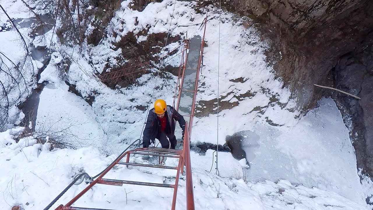
Stan Valley Canyon in winter 130.8 km away. The Stan Valley is a picturesque canyon, even in winter. In fact, when the stream is frozen and covered with a layer of snow, exploring the canyon becomes much quicker and easier.
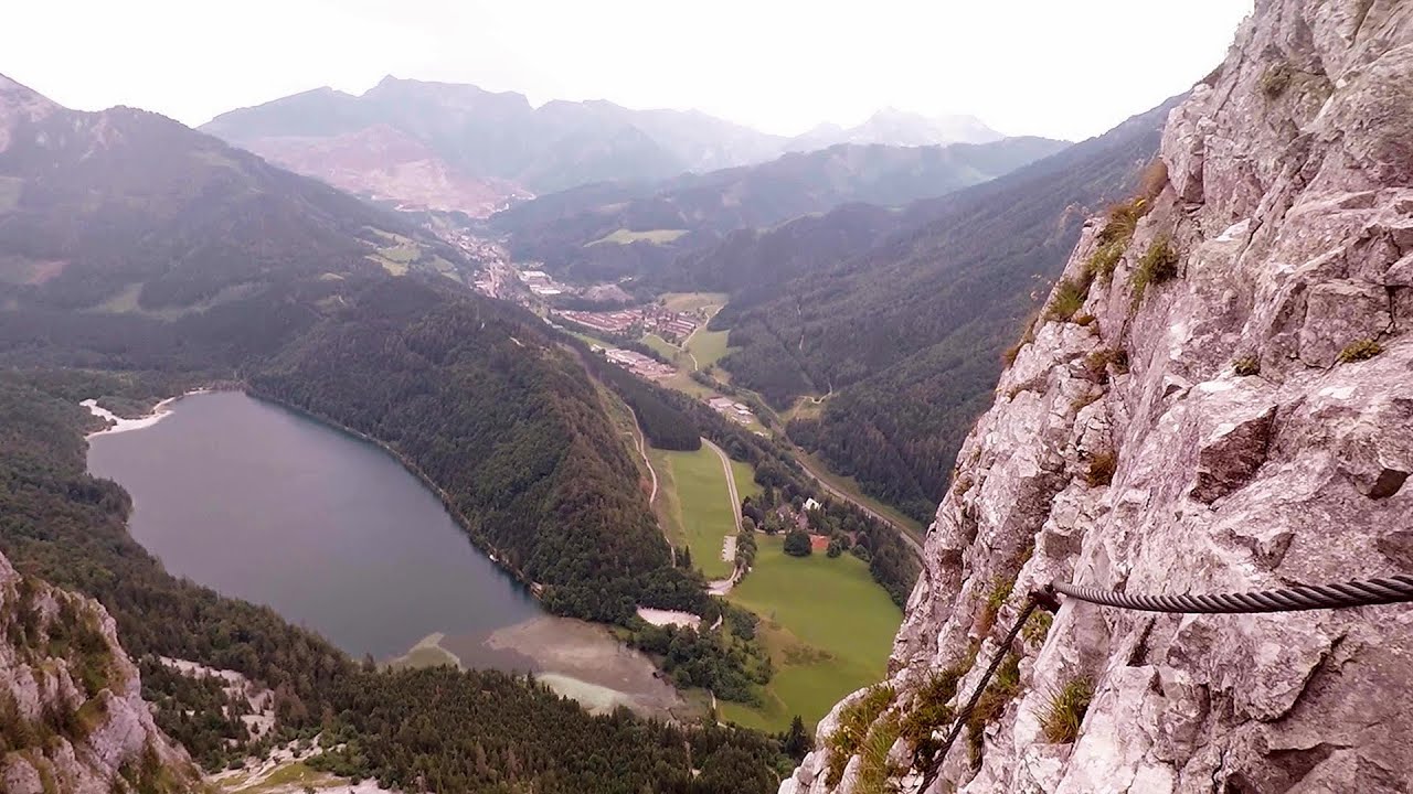
Kaiser Franz-Josef Klettersteig Leopoldsteiner See The Franz-Josef Klettersteig is located on the Seemauer cliff face, which rises 900 meters above Leopoldsteiner Lake, in the western part of the Hochschwab mountain range, just 4 km from the town of Eisenerz. This via ferrata is named after the Kaisersteig, a hunting trail established for the esteemed Emperor Franz Joseph I of Austria and Hungary at the end of the 19th century, traces of which can still be observed today.

Vulva cave Rhodope Mountains 496.5 km away. The Vulva Cave (Peshtera Utroba) is situated near the village of Nenkovo and the city of Kardzhali, in the Rhodope Mountains of Bulgaria. It derives its name from the shape of its entrance, which resembles a vulva.
Gornjak via ferrata and Kudelinovs fortress Zdrelo 398.2 km away. Difficulty level C/D, total length: 400 m, height difference: 330 m, year of construction: 2019, total length of the route to Kudelinov's fortress: 1100 m. Access to the via ferrata is free.
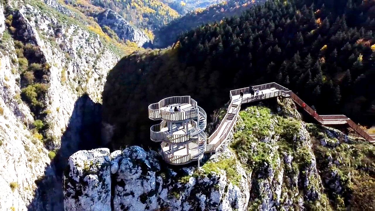
Valla Canyon Observation Deck Küre Mountains National Park Situated within Küre Mountains National Park, the Valla canyon is one of the deepest in Turkey, with a depth of 800 meters. The 12 kilometer long canyon was formed by the Devrekani Stream, which cuts through the Küre Mountains.
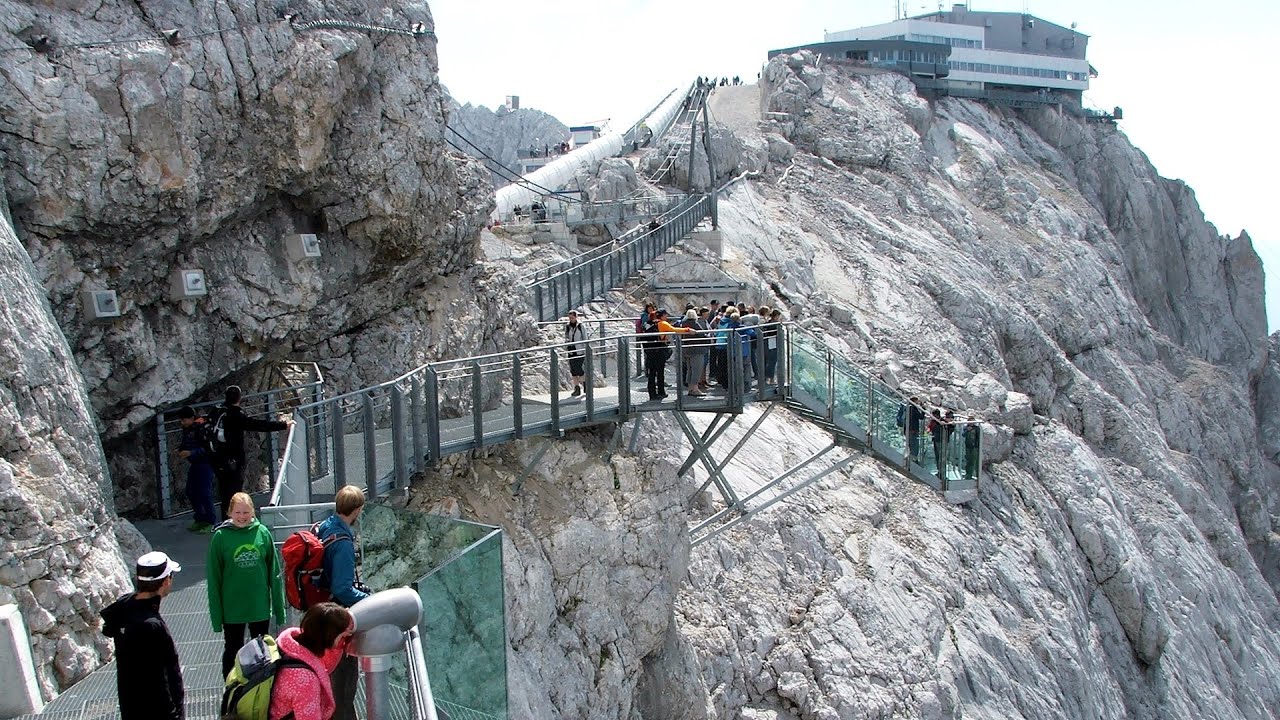
Sky Walk, Suspension Bridge, Stairway to Nothingness Styria, Dachstein The Dachstein cable car (Gletscherbahn Panorama Gondel, Panorama Cable Car) took me up to a height of 2700 meters, to the highest mountain in Styria (Steiermark), the Dachstein. Next to the upper station of the cable car there are several tourist attractions.
Skaklya waterfall Vratsa 376.9 km away. The largest seasonal waterfall in Bulgaria plunges down from a height of 141 meters. It is located in the Vratsa Mountain National Park, just one and a half kilometers away from the city of Vratsa.
Dalbina waterfall, Dark Blue Bruises of the Ponor 186.1 km away. Dalbina waterfall, Dark Blue Bruises of the Ponor (Vanatarile Ponorului).
[ Top ↑ ]
Copyright © 2003-2026 Trekkingklub and friends. Reproduction of any text, picture or video from this website, either in printed or electronic form, is prohibited without prior written permission. Website made with love  in Miercurea Ciuc.