Tourist attractions near Tulnici (Tulnici, Vrancea county, Romania)
Photos of nearby places


The waterfalls of Velnita stone-quarry - Left side (18 photos) 36.5 km away. Fan waterfall, Side waterfall, Double-decked waterfall, Waterfall with stairs, Hammock waterfall, Terrrace waterfall, The waterfall behind the arch, Suspended rock cube, Brown waterfall, Ceiling waterfall.

Surroundings of Covasna town (24 photos) 36.8 km away. Fortress of Fairies, Narrow gauge railway Covasna-Comandau

The waterfalls of Velnita stone-quarry - Right side (16 photos) 36.8 km away. The waterfall from the quarry, Green waterfall, Water-jet waterfall, Run down waterfall.

Round rocks from Viisoara - Berzunti (12 photos) 40.7 km away. Round rocks are quite a common curiosity, apart from those in Costesti, Valcea county, there are numerous other locations with similar rock formations. The round rocks from Viisoara are located northwest of the village, at a distance of approximately 700 meters from DC152 road.

White dacitic tuff - Manzalesti (4 photos) 48.1 km away. The 'Grunjul de la Manzalesti' is composed of dacitic tuff, which originates from volcanic ash. It is located in the center of the Manzalesti commune, Buzau county, at the confluence of the Slanic and Jgheab streams.


Beer waterfall - Gosmanu Ridge (12 photos) 65.6 km away. Beer waterfall (Cascada Berea) - Gosmanu Ridge, Tarcau Mountains.

Devils Hand Rock - Ciucas Mountains (30 photos) 66.7 km away. Dalghiu - Devil's Hand Rock - Ciucas peak - Vama Buzaului

Chiojdu (18 photos) 70.9 km away. Basca cu Cale - La Sipot waterfall - Basca fara Cale - Tata Lice boarding-house - Chiojdu village.

Muntele Rosu - Ciucas Mountains (12 photos) 72.8 km away. Muntele Rosu (Red Mountain) - Ciucas Mountains.

Red Mountain, Tigaile Mari - Ciucas Mountains (24 photos) 73.3 km away. Red Mountain - Tigaile Mari.

Altar, Handprint Rock - Gosmanu Ridge (17 photos) 76.3 km away. Altar, Handprint Rock (Stanca La deget) - Gosmanu Ridge, Tarcau Mountains.

Rock with fir trees - Gosmanu-Tarcau Mountains (21 photos) 76.8 km away. Rock with fir trees (Stanca cu brazi, Haystack Rock, Stogul de Piatra) - Gosmanu-Tarcau Mountains.

Rock with a cauldron - Gosmanu Ridge (10 photos) 77.2 km away. Rock with a cauldron (Piatra cu ceaun) - Gosmanu Ridge, Tarcau Mountains.

The sources of the river Trotus - Fagetel (10 photos) 77.9 km away. Fagetel, Piposz property, The sources of the river Trotus (Tatros).

Veczer Rock (12 photos) 79.6 km away. The Veczer Rock is located 3 km south of the village of Ariusd, on the southern slope of the place named Veczer. The tall hill is encircled by the Olt River, with conglomerate rocks resembling giants stretching above the river.

Ruins of the Harom fortress - Jigodin Bath (10 photos) 81.5 km away. The Harom Fortress was built around the beginning of the 12th century and was part of the system of fortifications that protected Transylvania from the east. It is located south of Miercurea Ciuc, east of Harom Peak, which has an altitude of 1079 m, near the southwestern limits of Jigodin Bath (Baile Jigodin).

Seven Ladder Waterfall - Piatra Mare Mountains (12 photos) 89.3 km away. The Seven Ladders are located in the middle-western part of the Piatra Mare Mountains, at an average altitude of 980 m, not far away from Valea Timisului (Dambu Morii), on the Seven Ladders River, the left-side affluent of Sipoaia creek. These are the greatest and the most spectacular gorges of the whole Piatra Mare Mountains.
[ Top ↑ ]
Videos of nearby places
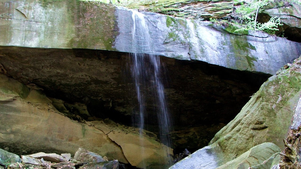
Waterfalls of Velnita stone-quarry - Targu Ocna 36.9 km away. Starting from the Velnita quarry, an adventurous nature enthusiast, accustomed to wild and rugged terrains, will discover a true waterfall paradise. At the upper part of the quarry, two streams converge.

Preachers Rock - Bodoc Mountains 61.4 km away. In the Bodoc Mountains, west-southwest from the Henter peak, we find a rock formation shaped like a mushroom by erosion, called Preacher's Rock. This 2-meter high rock probably got its name from the pagan Hungarian priests, who preached here in the past.

Saint Anne lake - Ciomat-Puturosu 65 km away. Lake Saint Anna is the only well-preserved volcanic crater lake in Eastern Europe. Here are some images from an afternoon outing.
Searching for rhododendrons - Ciucas Boulevard 72.1 km away. Red Mountain (Muntele Rosu), Gropsoarele-Zaganu ridge - Ciucas Mountains
Other places

Huda lui Papara cave Salciua de Jos 252.8 km away. Huda lui Papara cave (Paparas Hole) - Salciua de Jos, Trascau Mountains.
Fox Ears Beach Sinemorets 445.3 km away. Fox Ears Beach (Plazh Lisichi ushi) - Sinemorets.
Roman bridge Nenkovo 480.1 km away. Along the Borovitsa River, near the village of Nenkovo, there is a Roman Bridge. It connects the two banks of the Borovitsa River.

Cherven, a medieval fortified town Bulgaria 260.7 km away. Located about 30 km south of the city of Ruse in Bulgaria, the Cherven medieval fortress can be found in the Rusenski Lom Nature Park. Originally a Byzantine fortification from the 6th century, it reached the height of its development in the 14th century.

Via Ferrata Fairy Castle Vadu Crisului 339.6 km away. Via Ferrata Fairy Castle (Castelul Zanelor, Casa Zmeului, The House of the Dragon) - Vadu Crisului. South of Vadu Crisului, in the Padurea Craiului Mountains, lies the Vadu Crisului Gorge, a section of the Crisul Repede river that narrows between rocky walls.
Kaiserschild Klettersteig Eisenerzer Ramsau The 2,085-meter-high Kaiserschild peak is situated on the northern edge of the Eisenerz Alps in Styria, Austria. It forms a double summit with the slightly taller Hochkogel peak, which stands at 2,105 meters.
Óbányai Valley Eastern Mecsek The Óbányai Valley is located in the Eastern Mecsek Landscape Protection Area, stretching between Óbánya and Kisújbánya. Its attractions include the Slanting waterfall or Fairy Stairs, and the Dripping Rock.
Eagles Eye Yagodina Orlovo Oko (Eagle's Eye) is a lookout viewpoint located in the Rhodope Mountains, near the peak of Saint Ilia and close to the village of Yagodina, Bulgaria. The steel structure, built at an altitude of 1,563 meters, rises 670 meters above the spectacular Buynovsko Gorge, along with the winding river and road that traverse it.
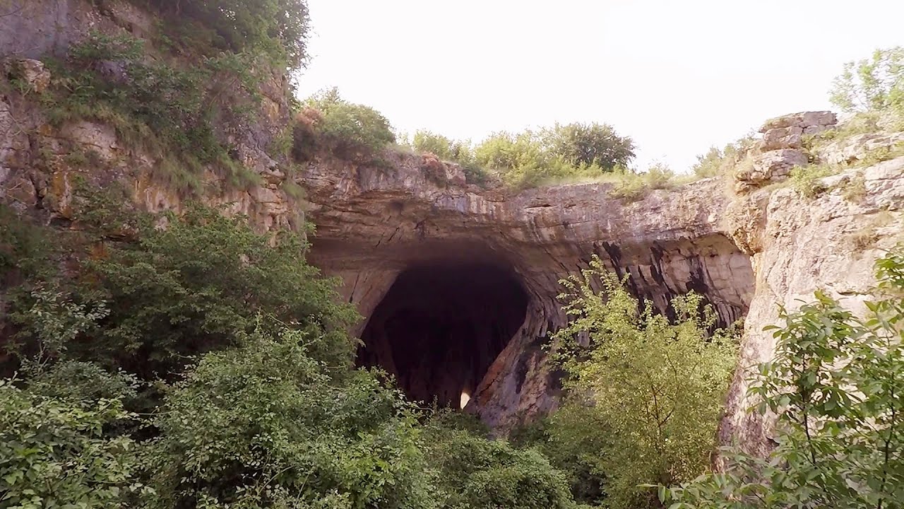
Prohodna cave Karlukovo 368.5 km away. The Prohodna cave nicknamed The Eyes of God is located in Bulgaria, in the Iskar Gorge, on one of the largest karst areas in Bulgaria, 2 km from the town of Karlukovo. It is essentially a 262-meter-long natural stone bridge, with a large (45 m high) and a small (35 m high) entrance.
[ Top ↑ ]
Copyright © 2003-2026 Trekkingklub and friends. Reproduction of any text, picture or video from this website, either in printed or electronic form, is prohibited without prior written permission. Website made with love  in Miercurea Ciuc.